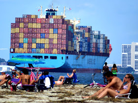
This was evident Sunday when my wife and I went to Sullivan's Island. At one point two massive container ships passed each other as one left the Charleston Harbor and the other one entered.
The two ships looked like they were on land, but in fact they were in the very deep water of the channel.
I took this photo as the huge Maersk ship was steaming into Charleston. Its size is magnified by the beachgoers nearby, many of whom barely paid attention to the site of the big ship passing.
This container ship, seen leaving Charleston, is called the Chicago Express. This link gives some information about the vessel, including its current location at sea or port.
Shipping activity in and out of the harbor happens in close proximity to the Sullivan's Island beach. It makes for some interesting viewing. I've always enjoyed taking photographs of the busy harbor boat and ship comings and goings.
Ships at sea are aided in navigating passage in and out of Charleton Harbor by the Sullivan's Island, which dates to the early 1960s is one of the last lighthouses erected by the U.S. government.
The much older Morris Island Lighthouse, near Folly Beach, can be seen from the beach at Sullivan's Island. The structure, which is no longer active, dates to 1870s. It was built on land, but beach erosion over the years has it now in the water.
A major stabilization and revitalization project, Save the Light, has helped ensure the Morris light's longevity.
There may not be too many warm summer days left to catch rays at area beaches. Alesia and I sure enjoyed this one. Seeing the two container ships was a treat.


No comments:
Post a Comment