

Now that Labor Day has come and gone, I’d like to share my favorite photos from several enjoyable Charleston area beach visits (with Alesia and a couple times with our son Joseph).

From my comfortable beach chair I watch the world go by. On a hot summer day there’s nothing better! On Sullivan’s Island we usually set up near the old Sand Dunes Club at Station 17 or 18.

I have called Sullivan’s Island the intersection of commerce and recreation. These photographs show you what I mean.
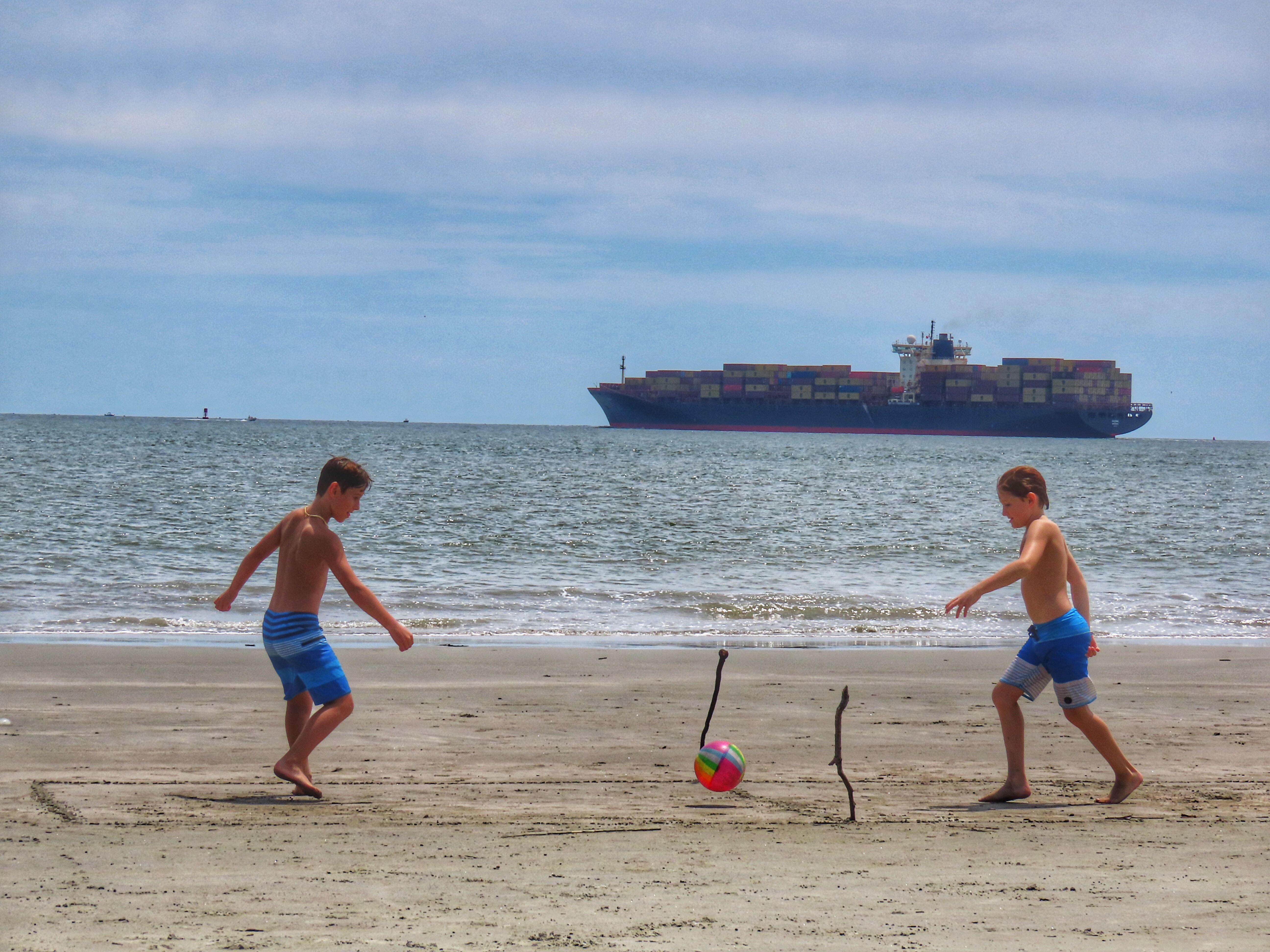
Sullivan’s is at the entrance to busy Charleston Harbor. Every day boats and ships of all shapes and sizes ply the waters going in and out of the harbor.

When the big boats cross paths, in this case one heading to port, one heading out to sea, they aren’t as close to each other as it looks from the beach.

Such huge container ships, stacked with cargo, are commonly seen seven days (and nights) a week.

Photos like this, taken on May 12, show how massive these ships are. Fully loaded they can carry from 5,000 to 25,000 20-foot containers. It’s no understatement that our economy and way of life depend on the imports and exports these ships transport.

This pink ship called One Cygnus sails under the flag of Tokyo, Japan. Built in 2019 it is 364 meters long and 50 meters wide. That length equates to almost 400 yards long or four football fields.

ONE stands for Ocean Network Express, a global container shipping company headquartered in Singapore.

Ocean Network Express has a fleet of 2,000 ships. Everything is big about this company! As I’m writing this post on Sept. 8, it looks like Cygnus One is back in a Charleston port, arriving from Jacksonville, Fla. over the weekend. Do a Google search of a container ship's name and you can quickly find out its current position. These sites do not indicate what the ships are carrying, which is something I'm always curious about. What is in all those containers?

I snapped this photo on the Ravenel Bridge on the way home from the beach. This container ship, aided by the tugboat behind it, is close to one of Charleston’s port facilities where it will be unloaded then, presumably, reloaded and refueled for its next voyage.

It continues to interest me- this casual and passive interaction between the mighty ships at sea and folks on the beach doing their thing whether swimming, sunning, reading, fishing or playing games.

On Aug. 25 a different type of ship cruised across the beach and into the harbor.

This is the car carrier Endurance, registry in Wilmington, Delaware. ARC stands for American Roll-On-Roll-Off Carrier. That aptly describes how vehicles roll onto and off the ship using the large ramp on the stern. Ships like this transport South Carolina-made BMWs, Volvos and Mercedes vans to ports around the world. On today’s date, Sept. 8, the Endurance is docked in Bremerhaven, Germany. It departed Charleston 13 days ago.


On duty for this mission is the Amy E. Hebert. The tug was built in Louisiana (Hebert does sound Cajun) back in 1969, was rebuilt in 1984, then again in 2014. Talk about a workhorse!


The Stingray was quickly and safely released. Glad of that and that no one was stung in the process.

This crab was not so fortunate RIP. Dead crabs and jellyfish are sometimes found on the beach.

I collected a few Sand Dollars from our most recent Sullivan’s Island excursion. If you are careful you can sometimes feel their distinctive outline with your toes when in the water. At home later I put them in a pail of bleach water to get that white color and remove any odors. I added them to this display in our downstairs bathroom.


Dedicated in 1962 and still in service, the Sullivan’s Island Light, as it is officially called, was first painted red-orange where it is now black. I do not think it has been repainted in the 34 years I have lived in the area. Might be time for a fresh coat of paint. Get on that U.S. Coast Guard!
Note the Shibumi Shades in this photo. You see them on beaches everywhere these days.

We’ve had one for a few summers now. It is lightweight, easy to set up, very sturdy and stable. A few college students in North Carolina created these shades. The creation has been very successful for them!

At low tide, it’s an expansive beach on Sullivan’s Island.

Lots of room to play and the water is shallow and mostly calm.

During low tide, there is plenty of sand for folks to spread out and have their own space.

I’ll always check the tide chart before a beach outing, hoping it will be low when we arrive, usually before noon, give or take. Sunday seems to be our favorite beach day.

A different day brings different tide levels.

On Aug. 25 the tide was very high. Dry sand was much less abundant.

I think the fishers (formerly known as fishermen) like the higher water.


This big sign, not far from the inlet to the harbor, is in feet of water at high tide.

Seen between the sign’s support poles two photos ago is this ferry that several times a day brings visitors to and from historic Fort Sumter where the first shots of the Civil War were fired in 1861.

A shrimp trawler and a NOAA research ship pass as beach goers enjoy the ocean on a warm summer day.

This is the National Oceanic and Atmospheric Administration’s Oregon II. It was commissioned in 1975, almost 50 years ago. The Oregon II is used to monitor and survey red snapper and sharks in the Atlantic Ocean. These and other fish are captured, measured, tagged, and released. That’s the Morris Island Lighthouse in the background.


One last Sullivan’s Island image before we go to another popular Charleston beach.
Station 17 at Sullivan’s Island is a great spot for beaching. It’s not hard to get to, is usually not too crowded, and the views of the boats, ships, and two lighthouses (Sullivan's and Morris Island at Folly Beach) are exceptional.


Joseph was with us so that was fun.

It is always nice to walk to the inlet to see the iconic Morris Island Lighthouse. With the boneyard beach here, the photo opportunities are awesome!

In this final photo you can see the Sullivan’s Island Light just to the right of the tall branch.

This sandy, scenic area is officially called Lighthouse Inlet Heritage Preserve, a Charleston County park.

Fall begins on Sunday, Sept. 22. I'm sure we will get to the beach a few more times in the months ahead! In coastal South Carolina can still be warm beach weather in late October.
No comments:
Post a Comment